Sept. 19
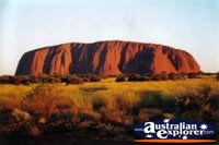
We arrived at Ayers Rock Airport in mid-afternoon, found our way to our cabin in the Ayers Rock Resort campground. It’s a whole new climate: desert clime, near 90F degrees. The pilot vectored in to his landing so as to give everybody a good view of Uluru (the Aborigine name, a.k.a. Ayers Rock -- the Aboriginal people now manage this area so the native place-names are more in use now), but the big event of evenings out here is sunset. We take the sunset tour along with about 2000 other folks.
We arrived at Ayers Rock Airport in mid-afternoon, found our way to our cabin in the Ayers Rock Resort campground. It’s a whole new climate: desert clime, near 90F degrees. The pilot vectored in to his landing so as to give everybody a good view of Uluru (the Aborigine name, a.k.a. Ayers Rock -- the Aboriginal people now manage this area so the native place-names are more in use now), but the big event of evenings out here is sunset. We take the sunset tour along with about 2000 other folks.

I was here 16 years ago, and wanted to come back on this trip. Such an impressive sight. I bought a t-shirt with statistics: height: 1141 ft., circumference: 6 miles. Here are a few of my shots this evening.


You can see better shots – more of a red glow, when atmospheric conditions are just right -- if you Google Uluru. (Because of limited internet access I’m not putting the links I usually do; you may have noticed. An exercise left for the reader.) Note that the layered sandstone that make up the rock run nearly perpendicular to the ground. During a period of violent upheaval this chunk of ancient seabed was tilted almost straight up. Eons of erosion uncovered what we now see as Uluru.
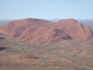
The next morning we take a helicopter flight over the area, flying by both Uluru and the nearby Kata Tjuta (Olga Mountains). And more. The third passenger on the trip is a researcher interested in getting a picture that shows Uluru, Kata Tjuta, and a far-off Mount Connor (perhaps not spelled correctly; I can’t find it on my map). They lie on a straight line and appear to be the remnants of an E-W mountain range through the center of Australia. We didn’t quite get the gist of his research objective, but it seemed to be the linkage of the Aboriginal theological beliefs with this mountain range. The continent is centered here and so are their beliefs. I think he wanted to generalize this observation to other religions. Brings to mind an earlier conversation about PhDs.

To get the desired alignment, Chris, our helicopter pilot, a pleasant young man from Scotland – he’d been here in this job two years -- took us to the west of the Olgas – a bonus ride of about 10 mins. -- so we could see the lineup of the Olgas, Uluru, and far off in the haze, mountain number 3. Didn’t quite have the visual effect our companion wanted, but it gave us some good sun angles for pictures of Kata Tjuta.

KT is a collection of 30-some sandstone domes, ranging up to quite a bit higher than Uluru. You can imagine this collection as a bunch of temples or tombs of minor gods progressing up to the major one(s).

Wait, there’s more. We were in a four-passenger helicopter, shown below. The good doctor’s wife was scheduled to take the trip but had to cancel because of illness. If she had come along we would have had to take a larger chopper, but one with less visibility for photography.
One more bonus: There were a couple of the Australian Air Force’s Hawk fighter jets on the runway when we took off. Chris told us they had been there for five or six days awaiting repair. We heard tower communication indicating the Hawks were ready to fly. Well, they took off just as we were descending, then came back around and screamed over the runway at 250 ft. just as we set down. Gave us front row seats. All in all, a thrilling morning, and only nine o’clock.
On the way back Chris said we should look for wild camels, but know that they are hard to see because of their camel-flage.
The rest of our morning was a little more mundane: we did some laundry, e-mail, phone calls, and packing. I wrote Susie while the laundry was going saying, Where’s a bloke’s mate when y’ really needs ‘er? (JUST KIDDING, I said, really. Having a great time but looking forward to home, too.)
Left Ayers Rock in mid-afternoon, bound for Cairns – the Great Barrier Reef and the Daintree River with Tonkawa’s other famous son, Dan Irby.
Cheers,
Rob


No comments:
Post a Comment